
When we think of Dwarven architecture in Tolkien’s legendarium, we often imagine vast halls, endless pillars, and cities carved deep beneath the mountains. Yet one crucial factor is often overlooked: the stone itself.
Not all mountains are alike. And for a people as practical, enduring, and craft-driven as the Dwarves, the nature of the rock would have fundamentally shaped how they built, where they built, and even how they lived. Tolkien’s world, while mythic, broadly follows real geological principles. Mountain ranges differ in composition, age, and formation, and these differences carry consequences.
If we take that seriously, Dwarven architecture would not be uniform, but determined by the geology it inhabits.
Erebor
Granite, Monumentality, and the Carved City
Erebor presents us with a key question: what kind of mountain is it?
Given its isolation and structure, sandstone and volcanic rock seem unlikely. Limestone is possible, but Tolkien never describes extensive natural cave systems within Erebor. Instead, what we see is deliberate, immense carving: vast halls, gates, and ordered spaces. This strongly suggests granite.
In visual adaptations such as The Hobbit, Erebor is often depicted with a distinct green tint to its stone. While this may mainly be an artistic choice, it also aligns with real geological possibilities. Granite can take on green hues through mineral content.

Given the presence of water within Erebor, such a green tint would in fact be plausible. It can be explained by chlorite-rich alteration of the host rock. Unlike Olivine (another greenish mineral), which breaks down in wet conditions and is generally incompatible with the high-silica environment of granite, Chlorite commonly forms within granitic systems through alteration processes, often replacing mafic minerals such as biotite and imparting a greenish hue to the rock. Rare iron-rich olivine (fayalite) can occur in specific granites, but this is exceptional and does not provide a convincing explanation for Erebor’s appearance.
This same water-driven system also provides a natural explanation for Erebor’s most defining feature: its gold. While massive granite alone is not an ideal host for large gold deposits, intrusive bodies are rarely uniform. As they cool and settle, they develop fractures, joints, and zones of weakness. These structures allow mineral-rich fluids to circulate through the mountain. Gold is then deposited along these fractures and intersections, forming veins and concentrated pockets. In such a system, the mountain is not a solid block, but a network of pathways through which fluids once moved, gradually enriching it from within.
Whatever liberties the Hobbit films may take elsewhere, the depiction of Erebor’s interior as green-toned stone threaded with gold veins is, in this respect, remarkably plausible. While chlorite contains iron, this does not contradict Erebor’s lack of iron resources. The iron within chlorite is dispersed and chemically bound, making it unsuitable as a source of workable iron ore. This allows Erebor to be rich in gold and mineral complexity, while still depending on external sources such as the Iron Hills for iron.
Regardless of colour, granite is hard, dense, and resistant to erosion. It does not form natural caverns easily. If Erebor is granite (which seems very likely), then everything within it must have been carved by Dwarven labour. This has major implications. There would have been almost no reliance on natural caves, but rather large, intentional excavation projects. The interiors would be clean and structured rather than resembling organic cave systems, and the entire complex would reflect a massive labour investment over time.
This aligns perfectly with the Erebor we see in The Hobbit. The kingdom is not a natural cavern expanded; it is a constructed interior world. But excavating granite creates a secondary effect: rubble. Once large volumes are carved out, enormous quantities of stone must be managed. And no, Ravenhill was not a rubble pile. For the Dwarves, the rubble would not be waste, but material. It is therefore highly plausible that, alongside carved halls, freestanding structures were built within larger excavated chambers using reclaimed stone.
Streets, stairways, and dwellings would form a true “city within the mountain”. As such, Erebor is not just hollowed out. It is constructed from within.
Khazad-dûm
Limestone, Water, and the Engineered Depths
Khazad-dûm presents a fundamentally different geological and architectural model from Erebor.
The presence of limestone in the region of the three peaks and Kheled-zâram is highly likely. In The Lord of the Rings, Book II, Chapter 6 (“Lothlórien”), Tolkien notes the presence of hart’s-tongue fern (Asplenium scolopendrium), a plant strongly associated with lime-rich, often magnesium-bearing limestone environments.
This is not a trivial detail. Limestone is chemically reactive. It dissolves in weak carbonic acid formed by rainwater and groundwater, gradually creating cavities, fissures, and extensive underground systems.
Khazad-dûm would have had both driving forces in abundance, as the Misty Mountains act as a climatic barrier, producing heavy rainfall and runoff, while continuous groundwater percolation moves through the rock. The mountain was therefore not static, but continuously shaped by water.
Because limestone caves form through dissolution, they are intrinsically tied to water. Flowing water carves passages, seeping groundwater maintains humidity, and condensation forms on cooler surfaces. Such environments are typically damp, humid, and thermally unstable. Unlike granite, which remains dry and largely inert, limestone creates a dynamic and reactive underground system. Left untouched, this would not be an ideal place to live.
Limestone cave systems tend to be extensive and interconnected, with multiple entrances across the mountain, numerous vertical shafts, and long corridors linking distant chambers. This naturally creates strong airflow. In colder periods, especially in winter, dense cold air sinks into lower sections and becomes trapped. Continuous circulation can amplify this effect, effectively turning parts of the mountain into a natural cooling system.
Without intervention, Khazad-dûm would have been cold in its deeper regions, persistently damp, and uncomfortable at scale. The features described by Tolkien are therefore not decorative luxuries, but necessary responses. The Dwarves introduced higher Levels, raising habitation above the coldest and dampest zones, along with windows and openings that connect interior spaces to the outside. Vertical shafts were created to provide both ventilation and light, while reflective systems, such as polished stone or mirrors, extended that light deeper into the mountain. Long corridors and structured layouts further helped regulate airflow. Together, these elements form a system of environmental control. They reduce dampness, stabilise temperature, and prevent the city from becoming the cold, humid environment that a natural limestone cavern would otherwise produce.
Khazad-dûm was organised into seven Levels above the Great Gates and seven Deeps below them, forming a vertically structured city. The eastern side, near the East-gate, was the most developed and populated. Here we find the First Hall, aligned with the gate and illuminated by daylight, along with light shafts bringing illumination into interior spaces, and carefully structured chambers forming the civic core.
Further within, on the Seventh Level, stood the Twenty-first Hall and the Chamber of Mazarbul, both associated with Balin’s colony. These spaces are described as having “good air” and clear shafts, indicating deliberate ventilation and vertical connectivity. This confirms that Khazad-dûm was not simply excavated horizontally, but engineered as a vertical system, using natural caverns as the foundation for a structure suited to Dwarven needs.

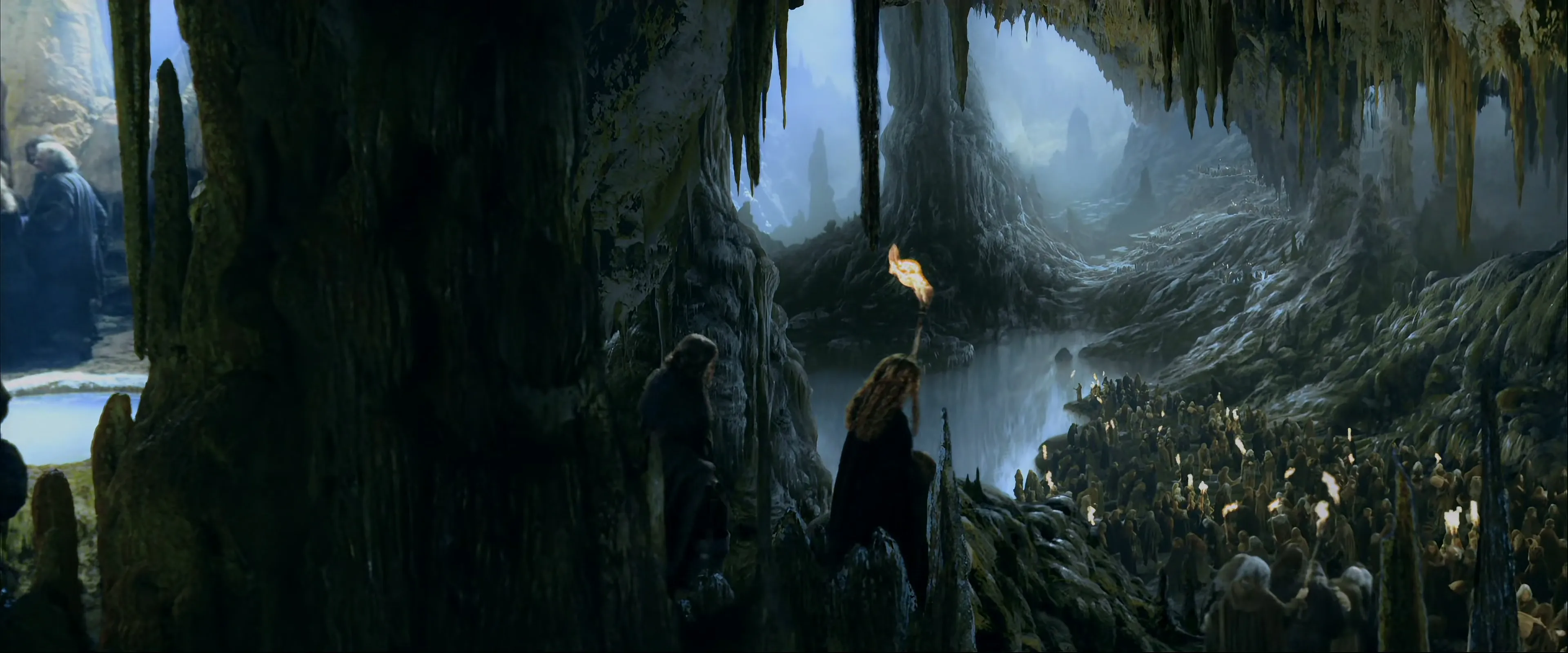
The Twenty-First Hall as depicted in The Lord of the Rings: The Fellowship of the Ring (2001).
The reference to the Twenty-first Hall invites an apparently simple interpretation. Since 21 is a multiple of 7, one might assume a system of three halls per level. However, Tolkien’s descriptions do not support such a rigid structure. The Second Hall was located in the First Deep, not on the First or Second Level, breaking any straightforward numerical mapping between halls and levels. Additionally, the Twenty-first Hall is described as being in the North-end of the realm. This implies spatial division. If a North-end exists, a South-end likely did as well. This suggests that hall numbering may have been regional rather than strictly vertical, that multiple parallel sections of the city may have existed, and that the number of halls per level was not fixed or uniform. Khazad-dûm was organised, but not symmetrical.
All of this aligns with a limestone-based system. The Dwarves did not carve Khazad-dûm from a solid block of stone. They encountered a vast, water-shaped cavern network and expanded and regularised it, connecting levels through shafts and corridors, stabilising ceilings with a great many pillars, and managing airflow, moisture, and light. Even the famous pillars take on a dual role. They are not only structural supports preventing collapse, but also help regulate airflow and create more stable interior zones.
Tolkien also makes a clear distinction between mining areas and city spaces. As the Fellowship travels through Moria from west to east, there is a noticeable transition, early passages are rough and irregular, while later spaces become ordered, illuminated, and architectural. This suggests that the deeper and western regions were primarily used for mining, colder and more humid, while the eastern and higher Levels were used for habitation, forming a more controlled environment. The mines likely extended further and deeper than any structured part of the city, following resources rather than design.
Khazad-dûm therefore represents a fundamentally different model from Erebor. Where Erebor is carved from solid, stable rock and is largely structurally predictable, Khazad-dûm is formed through water and dissolution, environmentally complex, and dependent on airflow, light, and vertical planning.
Its identity can be summarised as: A mountain that had to be mastered, not just carved.
Iron Hills
A City Grown out of Mined Layers
The Iron Hills are defined by their geology: a concentration of iron-rich deposits that determines how the mountain is worked and inhabited.
They are situated closer to the cold northern wastes, where the climate grows harsher and more exposed. To the east lie vast open lands, eventually giving way to more arid territories, while to the south the land opens into broader, often fertile plains, including regions such as Dorwinion and the lands surrounding the Sea of Rhûn. This places the Iron Hills at a natural intersection between harsh northern environments and more productive southern territories.
The hills themselves are the source of the River Carnen, whose name, “Red River”, already strongly suggests a high iron content in the surrounding geology, likely colouring the water through mineral runoff. This aligns with what is otherwise clear: the Iron Hills are rich in iron-bearing rock.
The Longbeard Dwarves of Khazad-dûm established colonies in the Iron Hills during the First Age, using them as a primary source of iron ore. From there, trade routes developed, including the north-eastern branch of the Dwarf-road through Mirkwood, connecting the Hills to Khazad-dûm and facilitating the movement of materials and goods between them.
Despite this wealth in iron, the Iron Hills were likely poor in other precious metals such as gold. As a result, their inhabitants, though prosperous and industrious, did not achieve the same level of accumulated wealth or splendour as seen in Erebor. Their prosperity was practical rather than opulent.
In real-world geology, large iron deposits are commonly associated with sedimentary systems, particularly ironstones and banded iron formations. These form through the gradual accumulation of iron-rich material in basin environments. While such processes in Arda cannot be assumed to follow real-world timescales, the structural outcome remains a useful model.
The Iron Hills align most closely with an ironstone-dominated basin system. Their relatively compact and self-contained nature, combined with their separation from the Grey Mountains, suggests that they are not remnants of a continuous mountain chain, but rather an independent geological formation. Though it may be tempting to view them as a remnant of the Iron Mountains, their position and structure indicate otherwise.
Their shape further supports this interpretation. The Hills appear to form a partial ring or enclosing structure, open toward the north-west, surrounding a lower interior region. This is characteristic of uplifted basin formations, where harder, mineral-rich layers resist erosion and remain elevated, while softer surrounding material is gradually worn away. The result is a natural concentration of iron-bearing strata along the elevated rim.
Within such a system, iron occurs not as isolated veins, but as continuous or semi-continuous layers embedded within the rock. These layers, composed primarily of iron-rich minerals such as hematite and magnetite, are interspersed with less valuable material, creating a stratified structure. At the same time, these layers are not uniform in quality. Localised processes, such as groundwater movement and weathering, can enrich certain zones, concentrating the iron and producing pockets of exceptionally high-grade ore.
A useful real-world analogue for this combination of layered structure and selective enrichment can be found in the Hamersley Range of Australia. There, iron-bearing formations are not uniformly valuable, but are enriched over time, creating zones of high-grade hematite within broader iron-bearing layers. This produces a landscape where ore quality varies significantly, and where extraction naturally concentrates around the richest deposits.
The visible horizontal iron-bearing layers of the Hamersley Range in Australia.
Applied to the Iron Hills, this suggests that Dwarven mining would not proceed evenly across the formation, but would focus on areas of highest concentration. Tunnels would expand around these zones, forming dense clusters of activity, while poorer layers would be bypassed or left only partially worked. The result is a dynamic internal structure shaped not only by the presence of ore, but by its distribution and quality. In such a landscape, architecture does not begin with space, but with resource. Dwarves here do not carve halls first and mine second. They follow the ore.
Because the geology is layered rather than fractured, mining proceeds along broad, predictable strata rather than narrow, irregular veins. This produces a fundamentally different internal structure, characterised by long, continuous extraction tunnels following iron-bearing layers, stepped levels corresponding to different strata, and predictable expansion along the geological formation, with large quantities of material removed in a systematic manner.
Chambers emerge where layers widen, intersect, or prove especially rich, rather than being imposed as primary architectural features. Over time, key areas are widened, reinforced, and formalised into halls, storage spaces, and working areas, but always within the logic dictated by the rock itself.
The layered structure of the Iron Hills naturally produces long, continuous extraction galleries as iron-bearing strata are worked horizontally. Once a band is exhausted, the resulting space forms an extended corridor, often uniform in height and direction. Rather than abandoning these spaces, the Dwarves formalise and integrate them into the structure of their settlements. These galleries become the primary routes of movement and transport, effectively functioning as the main arteries of the mountain.
From these long corridors, secondary chambers are cut into adjacent layers, creating storage areas, workshops, and living spaces. In this way, architecture develops outward from extraction rather than being imposed upon it. The result is a settlement composed not of singular grand halls, but of parallel, layered avenues connected by ramps and shafts, forming a dense and highly functional internal network.
Compared to Khazad-dûm, where construction responds more strongly to vertical fractures and natural cavern systems, the Iron Hills present a more readable, mainly angular and horizontally structured geology.
Unlike the monumental carving of Erebor or the engineered cavern system of Khazad-dûm, the Iron Hills would feel dense, very functional, and constantly active (as living quarters would be rather close to the mining activity – at least at first). Movement dominates the experience: ore being transported, tunnels being extended, supports being added, and routes shifting as layers are exhausted or newly discovered. There is little sense of a fixed or final form.
The material character reinforces this identity. Iron-rich dust settles across surfaces, exposed rock carries deep red and dark metallic tones, and freshly cut faces reveal dense, heavy strata. Water seeping through the rock often carries iron with it, staining channels and floors, echoing the same processes that colour the River Carnen.
While the iron carried by the River Carnen does not directly define the water used in cultivation, its influence may still be felt over far longer timescales through the gradual shaping of the land itself. As the river descends from the Iron Hills, it carries with it fine sediments derived from iron-rich strata, depositing them across the plains and lowlands that stretch toward Dorwinion. Over millennia, continuous iron mining by Dwarves in the Iron Hills would contribute to soils in Dorwinion that are not only fertile, but very mineral-rich.
In real-world viticulture, such soils, often marked by the presence of iron and other trace minerals, are known to support grape varieties that yield wines of greater depth, structure, and longevity. Rather than encouraging excessive growth, these conditions place the vine under a measure of natural restraint, leading to smaller yields but more concentrated fruit. Wines produced in such environments are frequently noted for their deeper colour, firmer tannic structure, and a richness that reflects both the soil and the climate in which they are grown.
In this way, the distant geology of the Iron Hills may subtly echo in the character of Dorwinion’s famed wines. Not through the immediate chemistry of the water, but through the slow and cumulative influence of sediment, soil, and time, linking the red-stained river of the north to wines of equally deep hue in the south, a visual and material continuity between mountain and vineyard.
As such, it is reasonable to conclude that the Dorwinion region was likely a strong producer of red wine varieties. The combination of mineral-rich soils, shaped in part by long-term sediment from the River Carnen, together with a continental climate marked by warm summers and cold winters, moderated by the nearby Sea of Rhûn, would naturally support grape types capable of producing deeply coloured, structured, and powerful wines, as such conditions favour the slow and complete ripening of grapes, allowing for the development of concentrated sugars, robust tannins, and a depth of colour often associated with wines of notable strength and longevity.
The position of the River Carnen is likely also central to the organisation of settlement within the Iron Hills. Flowing along the south-western edge of the range, it provides the most accessible and stable interface between the interior workings of the Hills and the wider lands beyond. Unlike the northern slopes, which are exposed to harsher climatic conditions, this region offers comparatively milder conditions and more reliable access.
For this reason, it is logical that the principal halls and primary points of entry would be established along or near the Carnen. Such a location would not only facilitate the removal of excavated material, but also enable direct connection to downstream trade routes leading toward Dorwinion and the lands surrounding the Sea of Rhûn. The river thus becomes both an outlet for production and a lifeline for supply.
Even on the more sheltered southern slopes, to some extent, the harsher northern climate continues to shape how the mountain is inhabited. Settlements must remain efficient, enclosed, and practical. The hills would be riddled with working tunnels, often closer to the surface, expanding horizontally and somewhat diagonally along mineral lines. The proximity of fertile southern lands further ensures that the Iron Hills are not isolated. Food and other organic resources can be sourced externally (through the road west to Erebor or the river south to Dorwinion), allowing the Dwarves to specialise almost entirely in extraction and production.
The Iron Hills represent something distinct within Dwarven civilisation: not a carved kingdom with layered monumental halls, nor an adapted cavern system, but a largely horizontal landscape in which the structure of the mountain itself is already ordered, and where Dwarven activity consists of following, exposing, and exploiting that order.
Blue Mountains
Coal, Craft, and the Industrial Foundations
The Blue Mountains, or Ered Luin, represent yet another model.
Formed in the early shaping of Arda after the destruction of the Two Lamps, and raised by the Valar, they belong to one of the oldest surviving mountain systems in Middle-earth. As such, they likely consist of mixed geology: metamorphic rock, numerous fractured zones, and sedimentary deposits shaped over time.
Their location is equally important. Positioned along the western edge of Middle-earth and exposed to maritime influence, the Blue Mountains would have experienced high levels of rainfall, particularly on their western slopes. As moisture-laden air rises against the range, it cools and releases precipitation, creating a persistently wet environment.
The Sindarin name Dolmed, the mountain where the founders of the Broadbeams and Firebeards established their Dwarven cities, means “wet hill”. This name predates the destruction of Beleriand, indicating that these maritime conditions were already present in earlier ages. The moisture would not have originated from the later Sea of Lhûn, but from the Great Sea to the west, with Beleriand lying between sea and mountains. As moist air crossed this fertile land and rose against the Ered Luin, it would have produced consistent rainfall along the range.
Although Belegost and Nogrod were established on the eastern side of the mountains, this does not contradict the pattern. The Blue Mountains are not of such height or continuity as to form a strong rain shadow, and moisture would have passed over and through the range rather than being confined to its western slopes. As a result, even the eastern side could remain well-watered, with local conditions, such as those reflected in the name Dolmed, likely shaped by persistent mist, runoff, and elevation rather than simple coastal exposure alone. The destruction of Beleriand did not introduce this pattern, but intensified it, transforming the Blue Mountains from an inland barrier into a coastal range, more directly exposed to maritime conditions.
Over time, such conditions lead to significant leaching of nutrients from the soil. Where the underlying rock does not counteract this process, soils tend towards acidity, particularly on exposed slopes and higher ground. This results in thinner, less fertile upland soils, with more productive pockets limited to valleys, terraces, and sheltered areas. Vegetation would favour hardy species such as birch, scrub, heath, and fern-rich undergrowth.
This is not a uniformly fertile landscape, but a selective one. In such conditions, settlement patterns shift. Rather than spreading evenly across the land, population and activity concentrate where resources, fuel, and workable ground are available. The great Dwarven strongholds of Gabilgathol (Belegost) and Tumunzahar (Nogrod) would therefore have been not only centres of craft, but true industrial hubs, closely tied to the availability of fuel and material.
They were also well connected to the east through a major trade route, often referred to as the Dwarven Road or the ancient Great East Road. This route linked them to Khazad-dûm in the Misty Mountains and extended further toward the Iron Hills. As a result, even where local resources were limited, the Dwarves of the West maintained reliable access to ore and materials through an established and far-reaching trade network.
This pattern of long-distance exchange is also reflected in earlier traditions. In The Lay of the Children of Húrin, the Dwarves of Tumunzahar are described as traders, bringing wine from Dor-winion, “bruised from the berries of the burning South”, over long distances to the northern lands, including Doriath. This is not incidental. It shows that the Dwarves of the Blue Mountains were not only producers, but active participants in wide-ranging trade networks, moving goods across vast distances.
In Unfinished Tales (“The Quest of Erebor”), Gandalf remarks that the Dwarves had been reduced in part to working as coal miners before the attempt to reclaim Erebor. Since they dwelt in the Blue Mountains at the time, this strongly suggests coal deposits in or near the Ered Luin.
Metalworking requires fuel. If ore, whether locally sourced or imported, and coal occur together, settlement patterns shift dramatically. One would expect integrated mining and smelting zones, large forge complexes, dedicated storage and transport infrastructure, and settlements organised primarily around production. Architecturally, this translates into less emphasis on monumental halls, especially in earlier phases, and a greater focus on workshops and furnaces, with settlements more widely distributed across the range rather than concentrated in singular grand spaces.
In real-world geology, however, coal forms from ancient plant matter over immense timescales, hundreds of millions of years. This far exceeds the internal chronology of Arda, which spans only thousands of years from its earliest ages to the end of the Third Age. If J.R.R. Tolkien intended Middle-earth to be a prehistoric phase of our own world, then the timelines do not align. There is simply not enough time within the history of Arda for coal and similar materials to form through natural processes as we understand them.
This leads to an important conclusion: Arda cannot be treated as a fully geologically consistent Earth. Instead, it is better understood as a mythic rendering of Earth, where natural processes resemble our own, but are not bound by the same timescales. Within this framework, materials such as coal are not the slow result of deep time, but part of the world’s original making. To the peoples of Middle-earth, such substances would not be “fossil fuels” in a scientific sense, but simply part of the stone, ultimately tied to the shaping of the world by their creator Mahal (Aulë) and the Valar.
The Blue Mountains therefore represent one of the first large industrial foundations of Dwarven civilisation, at least for the Firebeards and Broadbeams prior to the Second Age. Even in the Third Age, when the Longbeards established Thorin’s Halls, it is clear that mining remained at the heart of the settlement.
Before the First Age, however, the western context of the Blue Mountains was fundamentally different. To the west lay Beleriand, a vast and fertile land shaped by great rivers such as the Sirion. Unlike the exposed and selective environments of the Ered Luin themselves, Beleriand provided fertile soils, abundant freshwater, and extensive woodland and habitation zones.
The Blue Mountains therefore stood between two very different worlds: to the west, a fertile, river-fed landscape; to the east, a broader and more rugged interior. This positioning made them a natural interface between extraction and support. The Dwarven cities of Gabilgathol and Tumunzahar were not isolated industrial centres, but part of a wider system in which food and organic resources could be sourced from the west, while metals, crafted goods, and trade moved in both directions.
The destruction of Beleriand at the end of the First Age fundamentally altered this balance. The Blue Mountains, once central, became a western edge, more exposed and increasingly dependent on eastward connections.
The hydrology of the region reinforces this picture. The River Lhûn rises in the Blue Mountains and drains much of the surrounding land, forming a major natural corridor between the mountains and the interior. Such a system would not only intensify erosion and nutrient leaching, but also create valleys and routes that naturally lend themselves to travel and trade. The Dwarven Road, or its later reconstruction, may therefore not have been imposed upon the landscape, but guided by it.
The river Lhûn near its source, as seen in LotRO
Geologically, the Blue Mountains would not present a uniform rock mass, but a complex assemblage typical of an ancient, reworked range. Metamorphic rocks such as gneiss and schist likely form the structural backbone, characterised by layered compositions and natural planes of weakness. These are interspersed with more stable intrusive bodies, such as granite, as well as softer sedimentary deposits, including coal-bearing strata.
This variation would have had a direct impact on Dwarven construction. Larger halls would be preferentially excavated in more stable, massive rock, while corridors and secondary chambers would follow the natural grain of metamorphic formations. Softer and less stable layers would be reserved primarily for extraction rather than habitation. The result is an architecture that responds closely to the material itself, producing interiors that are segmented, directional, and visibly structured by the geology in which they are set.
This approach may also have influenced their survival during the ruin of Beleriand. While their cities were ultimately abandoned and their people displaced, the deliberate placement of their main halls within the most stable rock would have reduced the likelihood of sudden catastrophic collapse. Such resilience would not have preserved the cities themselves, but it may have allowed time for evacuation, helping explain how substantial numbers of the Firebeards and Broadbeams endured and later joined the Longbeards in Khazad-dûm.
The interiors of Gabilgathol and Tumunzahar would therefore have differed markedly from both Erebor and Khazad-dûm. Rather than vast, unified spaces carved from a coherent rock mass, or expansive natural caverns shaped by water, the halls of the Blue Mountains were likely developed within a fractured and moisture-rich mountain system. This produces a network of interconnected chambers and corridors, expanding along natural lines of weakness in the rock.
Persistent dampness, reflected in the name Dolmed, would necessitate careful management of water through drainage channels, sloped floors, and controlled runoff systems. At the same time, the presence of coal and large-scale metalworking imposes strong structural requirements: ventilation shafts, separated airflow systems, and layouts organised around the movement of raw and finished materials.
The result is an architecture defined less by monumentality and more by function, with medium-sized halls, distributed complexes, and a clear vertical organisation separating habitation, production, and extraction. Light, where present, would be guided deliberately through shafts and reflective surfaces, illuminating key spaces rather than flooding vast interiors.
Glittering Caves of Aglarond
A Realm Formed by Water, Preserved by Judgment
The Glittering Caves of Aglarond lie within the White Mountains behind Helm’s Deep. Unlike the Iron Hills or Khazad-dûm, their defining feature is not extraction or engineered space, but the natural formation of the mountain itself. These caves are best understood as a limestone, or karst, system. In such landscapes, slightly acidic water slowly dissolves the rock over long periods, carving out caverns, chambers, and passageways. Space here is not created through effort, but revealed through time.
This aligns closely with their real-world inspiration, the caves of Cheddar Gorge, particularly Gough’s Cave and Cox’s Cave, which J. R. R. Tolkien visited and later cited as the basis for Aglarond. These are limestone caverns shaped by water flow, mineral deposition, and gradual erosion, producing both vast chambers and intricate formations.
The geology of the White Mountains supports this interpretation. The range is widely understood to be composed primarily of limestone, giving rise to a karst landscape characterised by caves, sinkholes, and underground water systems. Their pale, “cold-gleaming” appearance reflects this composition, distinguishing them from the darker and harder stone of other ranges.
Within such a system, water is the primary architect. The Deeping-stream, which flows out of the Deeping-coomb, strongly suggests that its source lies within the caves themselves. This implies an extensive internal network of flowing water, pools, and channels that continue to shape the caves even as they are inhabited.
The interior of the Glittering Caves is therefore defined by large, irregular caverns formed by dissolution rather than excavation, by flowing water, pools, and constant dripping, and by stalactites, stalagmites, and mineral formations built up over time. Surfaces are smooth and rounded rather than sharply cut, reinforcing the sense that these spaces are not carved, but formed.
These spaces do not resemble halls. They resemble landscapes. It is this natural formation that gives the caves their defining character. Mineral-rich water deposits calcite across surfaces, forming crystalline layers that catch and scatter light. Walls shimmer, ceilings glow, and formations reflect illumination in shifting patterns. The “glittering” is not ornament, but a natural property of the stone itself. It is at this point that geology gives way to culture.
When Gimli beholds the caves, his response is not one of opportunity, but of recognition. He does not speak of mining them, nor of extracting their value. He describes their forms, their light, and their beauty, and resolves that they should be preserved.
This reflects a fundamental distinction within Dwarven thought: not all stone is meant to be worked. The Glittering Caves are not a resource to be exploited. They are a form already perfected. When the Dwarves of Erebor later settle Aglarond, their role is therefore not to reshape the mountain, but to inhabit it with restraint. Their interventions would be minimal and deliberate, consisting of stabilising pathways without altering natural formations, creating access routes that follow existing space, placing structures where they do not disrupt the natural flow of the caverns, and using light to reveal rather than compete with the reflective surfaces. Architecture here does not dominate. It yields.
This stands in contrast to other Dwarven realms. In Khazad-dûm, space is engineered. In the Iron Hills, it is extracted. In Aglarond, it is preserved. This distinction reveals something essential about Dwarven culture. Dwarves do not treat all stone equally. They distinguish between stone that serves practical purpose and stone that embodies beauty and form. The former may be cut, shaped, and used, while the latter is recognised, respected, and left largely intact.
This principle extends beyond the Glittering Caves themselves. Even in resource-rich environments, Dwarves would not strip mountains indiscriminately, collapse stable formations without reason, or destroy structures of exceptional natural beauty. Instead, their approach implies selective extraction, respect for structurally sound formations, preservation of remarkable natural features, and long-term planning of space and stability.
This restraint helps explain the longevity of Dwarven realms. Their endurance is not only the result of technical mastery, but of judgment. The Glittering Caves represent the clearest expression of this principle. They are not a city imposed upon stone, but a recognition of stone as something already complete.
Where this balance was not maintained, the consequences could be severe. In Khazad-dûm, the pursuit of mithril drove the Dwarves ever deeper, until they disturbed Durin’s Bane. As their own accounts state, they “delved too greedily and too deep.” The fall of Khazad-dûm thus stands as a direct result of overreach, not as a failure of skill, but of restraint.
The climatic conditions of the region further clarify how the Glittering Caves could be inhabited. Situated at the foot of the White Mountains near Helm’s Deep, the area experiences cold winters, significant rainfall, and strong, channelled winds. Left entirely untouched, a limestone cavern system of this kind would be cold, damp, and subject to continuous airflow, particularly in deeper or more exposed chambers.
The Dwarves, however, do not simply leave the caves in their raw state. Their restraint is not the absence of intervention, but the refusal to alter what is essential. Instead of reshaping the caverns themselves, they control the conditions within them. Airflow would be regulated by sealing or narrowing exposed passages, and entry points would be carefully controlled to limit wind and temperature loss. Water would be diverted or channelled to prevent excessive dampness, while localised heating would be introduced in inhabited areas. Within the larger caverns, enclosed living spaces would be constructed to create stable and habitable environments.
In this way, the caves remain visually and structurally intact while becoming habitable. The great chambers continue to exist as they were formed, but within them, smaller, controlled environments are created where Dwarves can live and work. This approach preserves the defining character of Aglarond. The mountain is not reshaped into a city, but made liveable within its existing form.
It also reinforces the underlying cultural principle. Dwarven restraint does not mean passivity. It means knowing what must not be changed, and applying skill only where it is necessary. This approach has a direct consequence for how space is organised within the Glittering Caves. Because the Dwarves do not impose large-scale restructuring upon the caverns, habitation must adapt to the natural distribution of space. Unlike Khazad-dûm, where halls are arranged in dense, vertically layered systems, Aglarond develops in a more dispersed and irregular manner.
Large chambers may be separated by narrower passages or changes in elevation, and not all spaces are equally suited for habitation. As a result, living areas, working spaces, and routes of movement are distributed across the cave system rather than concentrated into a single, unified structure. Some chambers may remain largely untouched, valued for their beauty, while others are selectively adapted for use.
The settlement therefore does not present itself as a compact city, but as a network of inhabited spaces embedded within a larger natural landscape. Movement between these spaces becomes an essential part of daily life, and the experience of the caves remains one of scale, distance, and variation rather than controlled uniformity.
There is also a strong possibility that development did not remain confined to the natural caverns alone. The Thrihyrne, the three steep-sided peaks rising above Helm’s Deep, form the solid mountain mass into which the caves extend. While the caverns themselves are preserved, the surrounding and overlying rock provides more structurally stable material for deliberate construction.
In this context, expansion does not take the form of reshaping the caves, but of extending beyond them. The Dwarves may have driven passages upward and outward into the body of Thrihyrne, creating more regular halls, storage areas, and defensive structures in the solid rock above and around the natural system. This produces a vertically layered relationship distinct from that of Khazad-dûm. The lower levels remain defined by natural caverns, wide, irregular, and largely untouched, while higher levels become increasingly structured and deliberate, shaped where the stone allows it without compromising the integrity or beauty of the caves below.
Aglarond was therefore likely not a purely horizontal nor purely natural settlement, but possibly a composite one: a preserved cavern system at its core, with a more controlled and constructed extension rising into the mountain above and the further chambers horizontally. In this way, the Dwarves do not alter what is already formed, but build where the mountain still invites their hand.
Grey Mountains (Ered Mithrin)
A Realm of Fracture, Fire, and Hidden Wealth
The Grey Mountains form a cold and rugged range in the north of Middle-earth, representing the surviving western reaches of the ancient Iron Mountains. As such, they are among the oldest geological structures in Arda, shaped by immense forces and long ages of upheaval.
A useful real-world comparison for this type of mountain system can be found in the Wrangell Mountains. There, an ancient geological foundation is overlaid and reshaped by extensive volcanic activity, producing a complex structure of hard crystalline rock, volcanic flows, and mineral-rich zones formed through heat and pressure.
A similar model can be applied to the Grey Mountains. Their deep structure would consist of ancient, erosion-resistant rock, granite, gneiss, and other metamorphic formations inherited from the original Iron Mountains. Upon this foundation, later volcanic activity, particularly in regions such as the Withered Heath, would have introduced layers of basaltic and andesitic material, as well as intrusive bodies such as diorite and related rock types.
This combination creates a highly varied geological environment. Rather than a uniform structure, the mountains consist of contrasting materials, hard crystalline cores, volcanic layers, and zones of thermal alteration. It is precisely along the boundaries between these materials, as well as within fractures and fault lines, that mineralisation would be most intense.
Ered Mithrin in LotRO
Unlike regions shaped by marine deposition, the Grey Mountains lack extensive sedimentary layering such as limestone or shale. Their structure is instead defined by deep geological processes and later volcanic overprinting, resulting in a harsher, more irregular, and more mineralogically complex environment.
This fractured nature means the Grey Mountains were not merely shaped by gradual geological processes, but by catastrophic events in the history of Arda itself. When the Iron Mountains were broken at the end of the First Age, the violence of that upheaval would have shattered the mountain mass, creating vast networks of faults, fractures, and weakened zones throughout the surviving range. These fractures are not incidental features. They are the defining structure of the mountains.
Over time, these deep breaks in the rock provided pathways for heat and mineral-rich fluids rising from within the earth. In regions such as the Withered Heath, this process may have been intensified by volcanic or magmatic activity. Such conditions are ideal for the formation of hydrothermal systems, in which heated fluids deposit metals as they cool within the surrounding rock. In this way, the ancient violence that broke the mountains becomes the very reason for their later wealth. The riches of the Grey Mountains are not simply found within them; they are the consequence of their breaking.
In Middle-earth, however, such processes need not unfold over vast, unbroken ages. The great upheavals that shaped the world, the raising of mountains, the breaking of lands, and the release of fire from within the earth, may have brought about in short measure what in other worlds would require long ages to achieve. The concentration of metals need not be the result of slow accumulation alone, but of sudden and violent conditions under which heat, pressure, and movement combined.
This explains their mineral wealth. Rather than occurring in broad, continuous layers, metals such as gold, lead, and silver are concentrated in veins, cutting through the rock in irregular and often unpredictable patterns. Iron remains present, but it is the presence of these heavier and more complex metals that distinguishes the region.
Lead, in particular, would have played a crucial role. In real-world metallurgy, it is used in processes such as cupellation to separate silver and gold from ore. Its presence alongside precious metals in the Grey Mountains strongly supports the existence of such refining practices among the Dwarves who settled there.
When the Dwarves under Thorin I came to the Grey Mountains in the Third Age, they found them rich in gold and largely unexplored. Yet this wealth came at a cost. The nature of the deposits meant that mining could not proceed in broad, predictable patterns, but required constant adaptation. In such a landscape, Dwarves follow veins rather than layers. This produces a distinct internal structure, characterised by narrow, winding tunnels tracing mineral veins, vertical shafts linking different levels of ore, and irregular branching networks shaped by geological fractures, with frequent reinforcement required in unstable sections.
Unlike the ordered expansion of the Iron Hills, Halls in the Grey Mountains would feel fragmented and complex. Routes shift, dead ends are common, and new discoveries may lie hidden behind seemingly unremarkable walls.
At the same time, the harsh northern climate and elevation impose significant constraints. Surface conditions could be bitterly cold, exposed, and often hostile, encouraging inward development for shelter and protection. For most peoples, such conditions would be prohibitive; for Dwarves, whose endurance in both heat and cold is well attested, they represent not a barrier to survival, but a factor to be managed.
However, the internal environment of the Grey Mountains is not uniformly cold. The same fractures and deep geological activity that produced their mineral wealth also allow heat from within the earth to rise through the mountain. In regions influenced by volcanic or hydrothermal activity, this creates pockets of elevated temperature, warming surrounding rock and air.
The Dwarves would have recognised and exploited these zones. Rather than driving uniformly deeper simply for insulation, they favour areas where natural heat is present, establishing halls, forges, and living spaces around these warmer regions. In this way, the mountain itself becomes a partial source of heat, reducing reliance on fuel and allowing sustained habitation even in a harsh northern environment. Yet this advantage comes with risk. These thermally active zones are not stable or evenly distributed. Heat may fluctuate, water may turn to steam, and structurally weakened rock becomes more prone to collapse. What provides warmth also introduces instability.
The organisation of space reflects this relationship with heat. Rather than anchoring their halls directly to unstable volcanic features, the Dwarves establish their principal spaces within thermally influenced but structurally sound zones of the mountain. Natural heat, rising through fractures and fissures, is captured and controlled through carefully managed channels, vents, and ducts. From these central, warmer halls, the settlement extends outward. Areas closer to heat sources house forges and workshops, while more distant zones lead into colder, irregular mining networks following mineral veins deeper into the mountain. The result is a layered but very uneven structure, defined not by symmetry, but by proximity to heat, stability, and resource.
The deepest and most unstable regions, where volcanic activity is strongest, remain largely inaccessible, serving both as a source of energy and as a constant reminder of the dangers beneath. This combination of geological instability, internal heat, and environmental harshness creates a fundamentally different kind of Dwarven realm. It is neither the engineered certainty of Khazad-dûm, nor the layered efficiency of the Iron Hills, nor the preserved balance of Aglarond.
Instead, the Grey Mountains represent a world of hidden wealth and constant uncertainty, where warmth and danger arise from the same source, and where every gain must be earned through risk, skill, and persistence. That risk would ultimately prove too great. Around T.A. 2589, in the wars with dragons, the Dwarves lost their halls and their king, and were driven from the Grey Mountains, forced to abandon both their wealth and the unstable mountain that had shaped their craft, their labour, and their fortunes.
Final Summary
Shaped by Stone
Taken together, these examples reveal a consistent underlying principle: Dwarven architecture is not defined by style, but by stone. Each great realm arises not from a shared blueprint, but from the material conditions of the mountain in which it is set. The differences between all of the discussed locations are not superficial variations, but the direct consequence of geology.
In Erebor, hard and stable granite allows for deliberate carving on a monumental scale, producing a city that is planned, structured, and constructed from within. In Khazad-dûm, water-shaped limestone demands control, giving rise to a vertically organised realm defined by airflow, light, and environmental management. In the Iron Hills, layered iron deposits dictate mostly horizontal expansion, resulting in a dense, functional network that grows directly from extraction. In the Blue Mountains, varied and moisture-rich geology, combined with the presence of coal, produces a distributed, industrial landscape shaped by production and trade. In Aglarond, water-formed caverns of exceptional beauty are not reshaped, but preserved, revealing a cultural boundary in how Dwarves engage with stone. The Grey Mountains stand apart as the most unstable of these environments, where fractured rock and internal heat create both great wealth and constant danger. Unlike Khazad-dûm, where peril lay deep and hidden, here the relationship between Dwarf and mountain is defined by immediate and persistent risk.
Across all of these though, a pattern emerges. Dwarves do not impose form upon the mountain without regard for its true nature. They read it, understand it, and work within its limits. Where the stone is stable, they carve. Where it is hollow, they regulate. Where it is layered, they follow. Where it is fractured, they adapt. Where it is already complete, they preserve.
This means that Dwarven mastery in carving or shaping their halls lies not merely in skill, but also in judgment. Their greatest works endure not because they reshape the mountain entirely, or deplete it from all its resources, but because they recognise what the mountain already is, and build in accordance with it, preserving what must be preserved. Not because they dig, but because they know when not to dig, and endure longest where that judgment is maintained. In this sense, the stone does not simply support Dwarven civilisation. It shapes it.
Note on terminology: Strictly speaking, “dwarvish” would be the more appropriate adjectival form, in line with Tolkien’s own usage. I have chosen to use “dwarven” nearly throughout, as it reads more naturally in this context.
